 | |||||||||||||||
|


 |
|
3:32 pm EST 37°F (3°C) in North Smithfield, RI
Calendar of Updates |
If memory serves me correctly, this is the first time I have ever set the parking brakes in Rhode Island. I have made a few trips through the state in the past, but all I think I have ever done here is pass right through on Interstate 95 on my way to points either north (Massachusetts) or west (Connecticut). I am currently getting unloaded at a facility that I would describe as being no farther than a Peter North cum shot from the Massachusetts state line.
I sure don’t know what I’m going to do with all of my winnings from Tuesday’s Mega Millions drawing … that’s right, all $2.00 of it.
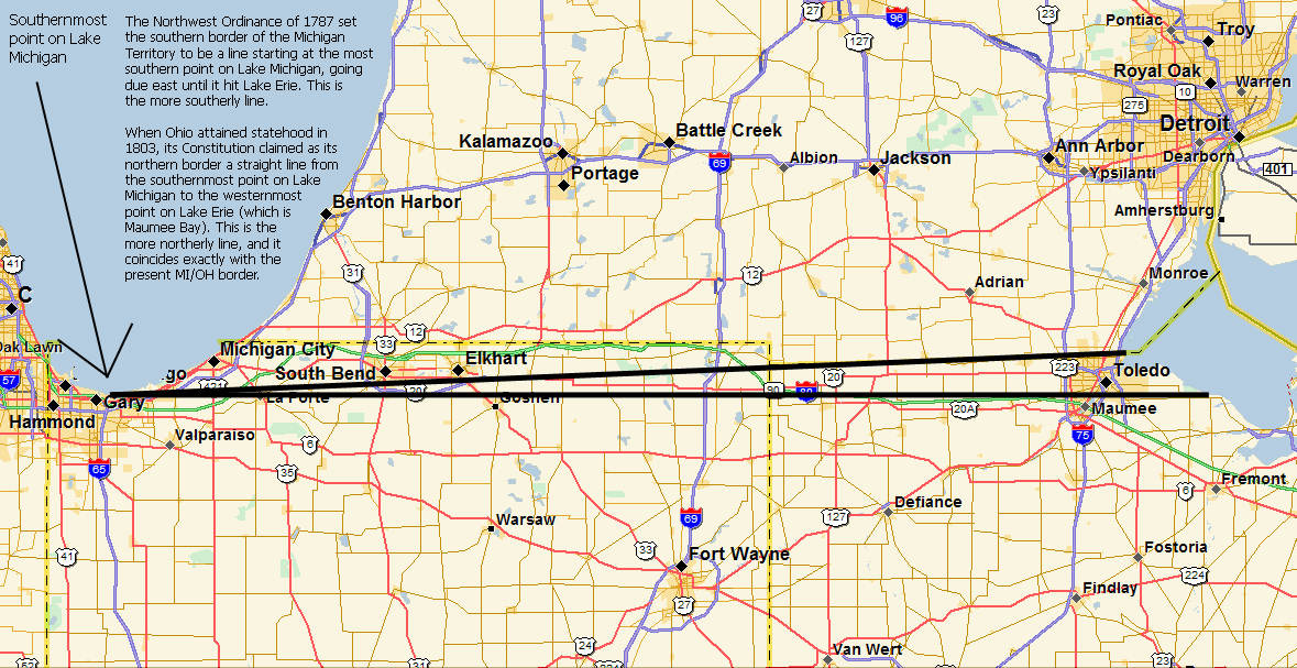
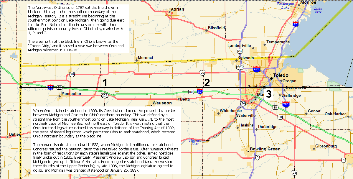
The other night, just in time for tomorrow’s Ohio State-Michigan football game at the Big House, I created a pair of GIF files that show just what evil, land-stealing, money-grubbing, good-for-nothing bastards those Buckeyes are. For those who don’t know the history, the Northwest Ordinance of 1787 (perhaps the only great piece of legislation to come from Congress under the Articles of Confederation) specified that a straight line, beginning at the southernmost point on Lake Michigan (near present-day Gary, IN) and going due east to Lake Erie, was to be the boundary for potential future states. In 1805, the Michigan Territory was created and defined as comprising all land north of this so-called “Ordinance Line.” The Ohio Territory began to seek statehood in 1802, and Congress passed a law called (appropriately enough) the Enabling Act of 1802. This law permitted Ohioans to draft a constitution and elect representatives to Congress, but it also explicitly re-stated Ohio’s northern boundary to be the Ordinance Line. The Ohio Constitution that took effect upon statehood in 1803 also said as much, but included this land-stealing provision: if the Ordinance Line intersected Lake Erie east of the mouth of the Maumee River, then “with the assent of Congress of the United States, the northern boundary of this State shall be established by, and extended to a direct line running from the southern extremity of Lake Michigan to the most northerly cape of the Miami [sic] Bay.” (The word “Maumee,” the modern name for that bay, is a linguistic corruption of Miami, which was the name of a Native American tribe that dominated western Ohio at the time.) The Ordinance Line as defined in the Northwest Ordinance was not surveyed accurately until John A. Fulton did so in 1818; Fulton did find that the Ordinance Line didn’t intersect Lake Erie until some 20 miles east of Toledo, in present-day Crane Creek State Park near the intersection of State Route 2 and State Route 19 in Ottawa County. This disagreed with an 1817 survey by William Harris, who was commissioned and paid by former Ohio governor Edward Tiffin; for reasons that should be obvious, Harris completed his survey in accordance with the extra provision in the Ohio Constitution (which, by the way, had never received “the assent of Congress of the United States”). This narrow disputed strip of land, which would come to be known as the “Toledo Strip,” remained essentially a no-man’s land between Michigan and Ohio until 1832. It was in that year of 1832 that the Michigan territorial legislature made its first petition to Congress for statehood. Congress cited the unresolved border dispute in turning down this petition, but also provided for a third survey to be completed by the Army Corps of Engineers. The results of this survey were nearly identical to those of the Fulton survey of 1818, bolstering Michigan’s claims to the Toledo Strip. In February 1835, the Ohio Legislature turned the heat up several notches by passing a law extending jurisdiction over the Strip; the stage was set for war. Armed hostilities would break out in April 1835, as Ohio Governor Robert Lucas traveled to the area to lead a surveying party. Michigan’s territorial governor, Stevens T. Mason, responded to the threat by ordering militiamen to the border; over the next five months, war would ensue. As a sort of “fuck you” to federal Secretary of State John Forsyth, who had been urging restraint and threatening presidential intervention if he felt it was needed, the Ohio Legislature created Lucas County (in which Toledo still exists today) out of the disputed area, naming it after their governor, and moved quickly to set up courts in Toledo. This hostile act essentially forced the hand of Congress, which proceeded to pass bills tying Michigan’s statehood hopes to its cession of the Toledo Strip to Ohio. The Michigan territorial legislature reluctantly agreed in late October 1836, and an act both (a) admitting Michigan as a state, and (b) compensating it for the Toledo Strip with the western ¾ of the present-day Upper Peninsula, took effect on January 26, 1837.
Even today, many Ohioans still refer to Michigan as “that state up north,” echoing the 1835 words of Major Benjamin F. Stickney, who used the term “the savage barbarity of the hordes of the north” in reference to Michigan citizens’ defense of their southern border. Although Michiganders aren’t as, shall we say, colorful in their description of Ohioans, the enmity and dislike are still palpable north of the state line as well. For my part, I just like to point out how the faux-military uniforms worn by the Ohio State University Marching Band prove that it is Ohioans who are the savage, militaristic bunch. Well, I’d better bring this one to a close, as several little tasks await. |

